

Dardanelles
Images
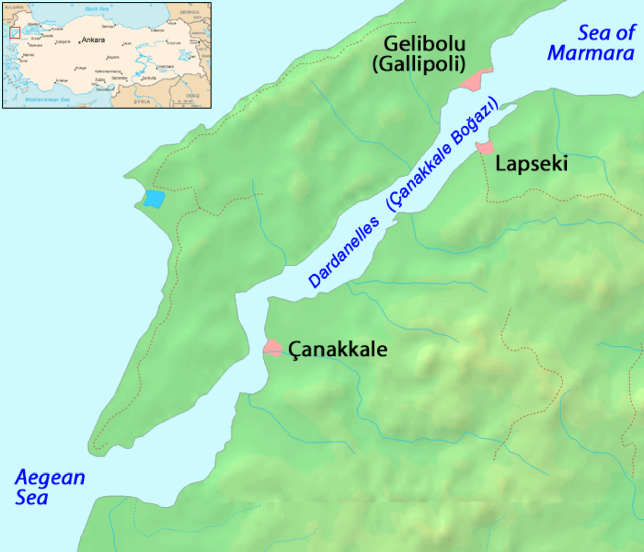
Dardanelles


Geopolitical Significance and Hydrological Dynamics
The Dardanelles, also known historically as the Hellespont, is a natural strait of immense geopolitical and geographical importance, forming a crucial segment of the Turkish Straits system alongside the Bosporus. It delineates the continental boundary between Europe and Asia, physically separating the Gallipoli Peninsula (European Turkey) from the Troad Peninsula (Asian Turkey). This narrow waterway is one of the world's most critical international navigation routes, connecting the inland Sea of Marmara to the Aegean and Mediterranean Seas.
Its hydrological characteristics are complex, with surface currents flowing from the Marmara towards the Aegean and deeper, saltier currents moving in the opposite direction. The strait’s dimensions are striking: 61 kilometers (38 miles) in length, with a width ranging from a mere 1.2 kilometers (0.75 miles) at its narrowest point to 6 kilometers (3.73 miles). Its average depth is 55 meters (180 ft), reaching a maximum of 103 meters (338 ft) near Çanakkale.
This confined geography makes it a bottleneck for maritime traffic, influencing naval strategy and international trade routes.
A Crucible of Civilizations and Conflict
The Dardanelles boasts a history stretching back millennia, deeply embedded in mythology and pivotal historical events. Ancient Greeks called it the Hellespont, immortalized in the myth of Helle falling into the sea. Its strategic value was recognized early on, serving as a gateway for trade and conquest between the Black Sea and the Mediterranean.
The Persian Empire, Alexander the Great, and the Roman Empire all understood its importance. During the Byzantine and Ottoman eras, control of the Dardanelles was paramount for defending Constantinople and projecting power. The most defining modern conflict associated with the strait was the Gallipoli Campaign of World War I (1915-1916).
An ambitious Allied attempt to seize control of the Dardanelles and open a sea route to Russia resulted in a brutal and costly campaign, particularly on the Gallipoli Peninsula. The campaign’s failure had profound consequences, including significant casualties for the Allied forces and a pivotal moment in the formation of modern Turkish national identity, solidifying its importance as a symbol of resistance and national pride.
Socio-Economic Landscape and Infrastructural Evolution
The shores of the Dardanelles present a contrast in settlement patterns. The northern Gallipoli Peninsula is characterized by its rugged terrain and sparse population, largely dedicated to historical sites and national parks commemorating the WWI battles. In contrast, the southern Troad Peninsula is more densely populated, dominated by the city of Çanakkale.
With a population of approximately 110,000, Çanakkale serves as the administrative and economic hub for the region, its economy intrinsically linked to the strait’s maritime activities, including shipping services, fishing, and tourism. The primary language spoken is Turkish. The region’s infrastructure has seen a monumental upgrade with the opening of the 1915 Çanakkale Bridge in 2022.
This suspension bridge, one of the longest in the world, spans the strait, providing a vital land link that bypasses ferry services and significantly enhances regional connectivity and economic integration between European and Asian Turkey, facilitating trade and travel.
Economic Lifeline
The Dardanelles functions as an indispensable economic artery for global commerce. As a key component of the Turkish Straits, it facilitates the passage of a vast volume of maritime trade, particularly for landlocked countries bordering the Black Sea, such as Russia, Ukraine, and Georgia, providing them with their primary maritime access to the Mediterranean and beyond. The strait’s narrowness and the high volume of traffic necessitate strict navigation protocols and contribute to shipping costs and transit times.
Its economic importance is underscored by the constant stream of oil tankers, cargo ships, and passenger vessels. The opening of the 1915 Çanakkale Bridge represents a significant infrastructural investment that aims to further boost economic activity by improving logistics and reducing transportation bottlenecks. This bridge not only eases land-based trade but also integrates the region more effectively into national and international supply chains, reinforcing the Dardanelles’ enduring role as a critical economic nexus.
Governance and International Maritime Law
The governance of the Dardanelles is primarily managed by Turkey, as it lies entirely within its territorial waters. However, its status as an international waterway means its navigation is subject to specific international agreements. The Montreux Convention Regarding the Regime of the Straits, signed in 1936, governs the passage of naval and merchant vessels through the Turkish Straits (Dardanelles, Sea of Marmara, and Bosporus).
This convention grants freedom of transit for civilian vessels in peacetime and regulates the passage of warships belonging to non-Black Sea powers. While Turkey retains sovereignty, the convention ensures that the straits remain open for international navigation under defined conditions. This legal framework is crucial for maintaining regional stability and facilitating global maritime commerce, balancing Turkish national interests with international access rights.
Go deeper
Frequently Asked Questions
What is the Dardanelles?+
Why is the Dardanelles important for ships?+
Where does the Dardanelles lie between Europe and Asia?+
What happened at the Dardanelles during World War I?+
What new bridge was built over the Dardanelles?+
Based on content from Wikipedia · Licensed under CC BY-SA 4.0