

Labrador Peninsula
Images

people from 'Explorations in the interior of the Labrador Peninsula, the country of the Montagnais and Nasquappe Indians'.


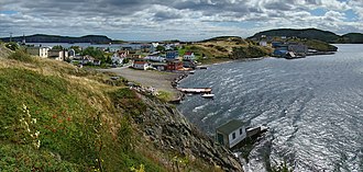
Defining the Eastern Canadian Frontier
The Labrador Peninsula, also known as the Quebec-Labrador Peninsula, represents a significant geographical and geopolitical entity in eastern Canada. Its boundaries are precisely delineated by major bodies of water: Hudson Bay to the west, Hudson Strait to the north, the Labrador Sea to the east, and the Strait of Belle Isle and Gulf of St. Lawrence to the southeast.
This vast expanse, covering an impressive 1,400,000 square kilometers, is not a single administrative unit but rather a composite region. It encompasses the entirety of Labrador, a territory that forms part of the province of Newfoundland and Labrador, alongside substantial portions of Quebec, specifically the administrative regions of Saguenay–Lac-Saint-Jean, Côte-Nord, and the vast Nord-du-Québec. This geographical configuration positions the peninsula as a critical transition zone between the more populated southern regions of Canada and the Arctic, influencing its climate, ecosystems, and human settlement patterns.
Ecological Diversity and Climate Extremes
The ecological character of the Labrador Peninsula is marked by its immense scale and latitudinal variation. The southern areas are dominated by extensive boreal forests, a biome characterized by coniferous trees and a rich understory, supporting diverse wildlife. Moving northward, these forests gradually transition into a subarctic environment and eventually into the Arctic tundra.
This treeless landscape, defined by permafrost and low-growing vegetation, experiences extreme cold and short growing seasons. The peninsula is crisscrossed by numerous major river systems, such as the Churchill River and the Romaine River, which are crucial for its hydrology and support significant hydroelectric power generation. The climate is continental, with long, severe winters and short, cool summers, particularly pronounced in the northern reaches.
This environmental gradient creates distinct habitats, influencing biodiversity and the types of human activities that can be sustained.
A Tapestry of Indigenous Heritage and Modern Settlement
The human history of the Labrador Peninsula is deeply rooted in the presence of Indigenous peoples, including the Innu and Inuit, who have inhabited this territory for millennia. Their traditional lifestyles were intricately adapted to the challenging environment, relying on hunting, fishing, and a profound understanding of the land's cycles. European exploration and settlement, beginning in the early modern period, introduced new dynamics, leading to resource extraction, trade, and the establishment of permanent communities.
Today, the peninsula is home to a diverse population, with English and French being the primary languages, reflecting its dual provincial administration. While significant portions remain sparsely populated and wild, urban centers and resource-based communities are focal points of economic and social activity. The ongoing relationship between Indigenous communities and the broader Canadian state continues to shape the cultural and political landscape of the region.
Resource-Driven Economy and Infrastructure Challenges
The economy of the Labrador Peninsula is predominantly driven by its abundant natural resources. Forestry has historically been a key industry, with vast timber reserves supporting pulp and paper production. The geological richness of the peninsula has led to significant mining operations, extracting iron ore, nickel, and other valuable minerals. Hydroelectric power is another major economic contributor, with numerous large-scale dams harnessing the power of its mighty rivers, supplying electricity to both provincial and export markets.
The surrounding marine environments also support important fishing industries. However, the sheer size and remote nature of much of the peninsula present considerable challenges for infrastructure development, transportation, and service provision, impacting economic diversification and accessibility for its inhabitants.
Governance and Future Development
The Labrador Peninsula's governance is complex, being divided between two Canadian provinces: Newfoundland and Labrador, and Quebec. This division means that different provincial laws, policies, and administrative structures apply to different parts of the peninsula. In Newfoundland and Labrador, Labrador itself is a territory with its own unique governance considerations, including significant self-government agreements with Indigenous communities.
In Quebec, the northern regions are vast and sparsely populated, with specific administrative bodies overseeing their development and resource management. The future development of the peninsula is a subject of ongoing discussion, balancing economic opportunities, particularly in resource extraction and renewable energy, with environmental conservation and the rights and aspirations of its Indigenous populations. Issues of land use, infrastructure investment, and interprovincial cooperation are central to its evolving trajectory.
Go deeper
Frequently Asked Questions
What is the Labrador Peninsula?+
Where is the Labrador Peninsula located?+
What kind of forests and animals live on the Labrador Peninsula?+
Which rivers are important on the Labrador Peninsula?+
Who lives on the Labrador Peninsula and what do they do?+
Based on content from Wikipedia · Licensed under CC BY-SA 4.0