

The Barents Sea: A Chilly Arctic Playground!
Images

Barents Sea


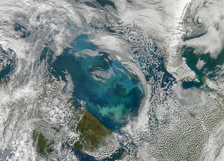
![Phytoplankton Bloom in the Barents Sea [Detail]](https://live.staticflickr.com/4110/4971318856_93be61dbaa_n.jpg)


Geographical Context and Oceanographic Characteristics
The Barents Sea is a significant marginal sea of the Arctic Ocean, situated north of Norway and Russia. It functions as a crucial transition zone between the colder Arctic waters and the warmer waters of the North Atlantic. Geographically, it is a relatively shallow shelf sea, with an average depth of approximately 230 meters (750 feet).
Its boundaries are defined by the Kola Peninsula to the south, the Norwegian Sea to the west, the Svalbard archipelago to the northwest, Franz Josef Land to the northeast, and Novaya Zemlya to the east. Novaya Zemlya, an extension of the Ural Mountains, forms a natural barrier separating the Barents Sea from the Kara Sea. The sea's bathymetry is characterized by a gentle slope from the coastlines towards the shelf edge, with deeper basins interspersed with shallower banks.
This unique topography influences ocean currents and the distribution of marine life.
Historical Naming and Exploration Legacy
Historically, the Barents Sea was known by various names among its coastal inhabitants, reflecting its prominent position in their lives. Russians referred to it as the 'Northern Sea,' the 'Pomorsky Sea,' or the 'Murman Sea.' The adoption of the name 'Barents Sea' in the 16th century commemorates the Dutch navigator Willem Barentsz, a pioneering explorer of the Arctic. Barentsz's expeditions, though arduous, significantly contributed to the geographical understanding of the region, including attempts to find a Northeast Passage.
His legacy is embedded in the very name of this sea, a constant reminder of the human drive to explore and chart the unknown, a spirit that continues to inform scientific and economic endeavors in the region today.
Economic Significance
The Barents Sea holds immense economic importance, primarily driven by its rich fishing grounds and substantial hydrocarbon reserves. It is one of the most productive fishing areas in the world, supporting significant cod and haddock fisheries that are vital to the economies of Norway and Russia. Beyond fisheries, the seabed of the Barents Sea contains vast deposits of oil and natural gas.
Extensive exploration and extraction activities are underway, positioning the region as a key contributor to global energy supplies. This dual reliance on marine resources necessitates careful management to balance economic development with environmental sustainability, a complex challenge given the sensitive Arctic ecosystem.
The Phenomenon of 'Atlantification' and Climate Change Impacts
The Barents Sea is recognized as an 'Arctic warming hot spot,' experiencing climate change at a rate significantly faster than the global average. A key phenomenon is 'Atlantification,' where warmer, saltier Atlantic water increasingly penetrates the Barents Sea, leading to a reduction in sea ice cover and changes in water stratification. This warming trend has profound ecological consequences, altering marine ecosystems, fish migration patterns, and the distribution of species.
Furthermore, increased evaporation from the ice-free areas is predicted to influence weather patterns across Eurasia, potentially leading to increased winter snowfall in continental Europe. The Barents Sea thus serves as a critical indicator of global climate change and its far-reaching impacts.
Geopolitical Landscape and Future Outlook
The Barents Sea lies at the intersection of Norwegian and Russian territorial waters and exclusive economic zones, making it a region of significant geopolitical interest. The potential for increased shipping traffic as Arctic ice recedes, coupled with the valuable natural resources, creates both opportunities and challenges. International cooperation is essential for managing shared resources, ensuring maritime safety, and addressing environmental concerns.
The ongoing transformation of the Barents Sea due to climate change underscores the need for adaptive strategies and continued scientific research to navigate its future, balancing economic imperatives with ecological preservation and international collaboration.
Go deeper
Frequently Asked Questions
What is the Barents Sea and where is it located?+
Why is the Barents Sea important for fishing and oil?+
How does the Barents Sea get warmer and what does that mean for sea ice?+
Who was Willem Barentsz and why is the sea named after him?+
What are the neighboring places around the Barents Sea?+
Based on content from Wikipedia · Licensed under CC BY-SA 4.0