

Roosevelt Island
Images

Roosevelt Island - New York City, New York


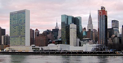


From Segregated Past to Integrated Present
Roosevelt Island, a slender landmass in the East River, represents a compelling case study in urban transformation. Its geographical isolation, situated between Manhattan and Queens, has historically dictated its function. Initially inhabited by the Lenape as Minnehanonck, it was later known to the Dutch as Varken Eylandt (Hog Island) and subsequently as Blackwell's Island and Welfare Island.
For over a century, its identity was defined by institutions like hospitals, prisons, and asylums, deliberately removed from the city's public consciousness. This era of limited access and specialized use profoundly shaped its infrastructure and perception. The island's lease to the New York State Urban Development Corporation (UDC) in 1969 marked a pivotal shift, initiating a comprehensive redevelopment plan that aimed to transform it into a mixed-use residential community.
This transition from a place of confinement and care to a vibrant neighborhood underscores a broader trend in urban planning, where underutilized or historically stigmatized areas are reimagined for contemporary living and community building.
Connectivity as a Catalyst
The successful integration of Roosevelt Island into New York City's urban fabric is intrinsically linked to its innovative transportation infrastructure. Beyond the standard subway and ferry services, the Roosevelt Island Tramway stands out as a pioneering element. This aerial tramway, one of the first of its kind in North America for public transit, offers not only a functional commute but also a unique perspective on the city's geography and architecture.
It serves as a visual and physical link, bridging the perceived gap between the island and the mainland. The presence of the Tramway, alongside the Franklin D. Roosevelt East River Drive bridge and ferry terminals, creates a multi-modal transportation hub that enhances accessibility and desirability.
This robust connectivity is crucial for a residential community, ensuring residents can seamlessly engage with the wider metropolitan area for employment, education, and cultural activities, thereby fostering a sense of belonging and opportunity.
A Planned Community
The redevelopment of Roosevelt Island, initiated in the 1970s, was a deliberate exercise in planned urbanism. The island was meticulously designed with distinct residential zones, Northtown and Southtown, featuring modern high-rise apartment buildings. This planned approach aimed to create a cohesive community with integrated amenities.
A significant addition in the 21st century is the Cornell Tech campus, a graduate research university focused on the intersection of technology, business, and society. This academic institution injects a dynamic, forward-thinking element into the island's identity, fostering innovation and attracting a diverse population. The island also preserves remnants of its past, with six New York City designated landmarks standing alongside contemporary structures, creating a unique architectural dialogue.
This blend of historical preservation and cutting-edge development highlights a sophisticated approach to urban design, balancing heritage with future aspirations.
Daily Life and Governance
Life on Roosevelt Island is characterized by a unique blend of community self-sufficiency and reliance on city-wide services. The island features essential amenities such as parks, including the contemplative Four Freedoms Park and a scenic promenade, an elementary school, and various houses of worship, all contributing to a strong local identity. Its infrastructure includes advanced systems like a pneumatic garbage-disposal system, reflecting a commitment to efficient and potentially sustainable urban management.
While some municipal services are coordinated through Queens, the island maintains its own post office, symbolizing its distinct community status. The governance structure, involving a long-term lease to a development corporation, has facilitated its transformation, but also raises questions about long-term urban management and resident participation. The island's evolution from an isolated institutional site to a modern, connected residential hub offers valuable insights into the complexities of urban planning, social integration, and the ongoing quest for livable, sustainable cities.
See also
Frequently Asked Questions
What is Roosevelt Island?+
Why does Roosevelt Island have a tramway?+
Where did Roosevelt Island used to be called Hog Island?+
How did Roosevelt Island change from a hospital and prison area to a residential community?+
What makes the Roosevelt Island Tramway special?+
Based on content from Wikipedia · Licensed under CC BY-SA 4.0