

Forth
Images

back&forth


Geomorphology and Hydrology of the Forth Basin
The River Forth is a principal river in Scotland, originating in the Trossachs and flowing eastward for approximately 47 kilometers (29 miles) before emptying into the North Sea via the Firth of Forth estuary. The river's drainage basin covers a significant portion of central Scotland, encompassing diverse geological formations. Its course is characterized by a series of meanders through lowland agricultural areas before widening into a substantial estuary.
The Firth of Forth is a classic example of a ria, a submerged river valley, shaped by glacial erosion and subsequent sea-level rise. This estuarine environment is ecologically rich, supporting diverse marine life and serving as a vital migratory route for birds. The tidal nature of the estuary significantly influences its salinity and water circulation patterns, creating a dynamic ecosystem that has historically supported fishing and maritime activities.
The Forth's geographical significance lies in its role as a natural barrier and a conduit for transport and trade, profoundly influencing settlement patterns and economic development across central Scotland.
The Forth Bridges
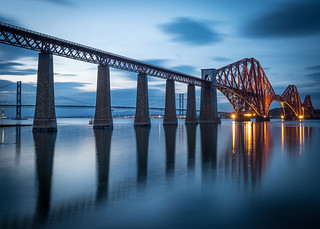
The Forth estuary is famously spanned by three iconic bridges, each representing a distinct era of engineering achievement. The Forth Bridge, a monumental cantilever railway bridge completed in 1890, was a groundbreaking feat of Victorian engineering, designed by Sir John Fowler and Sir Benjamin Baker. Its construction involved innovative techniques to overcome challenging ground conditions and immense scale, earning it a place as a UNESCO World Heritage site.
The Forth Road Bridge, a suspension bridge opened in 1964, modernized road transport across the Forth, significantly reducing journey times and boosting economic connectivity. Its design, while less visually dramatic than its railway predecessor, was a significant engineering undertaking for its time. The most recent addition, the Queensferry Crossing, opened in 2017, is a cable-stayed bridge designed to carry the M90 motorway.
It is the longest multi-span cable-stayed bridge in the world and incorporates advanced aerodynamic design to withstand high winds, a common feature in the region. Together, these bridges form a globally recognized ensemble of civil engineering landmarks.
Historical and Cultural Significance of the Forth Corridor
The Forth corridor has been a pivotal region in Scottish history for millennia. Its strategic location and the river's navigability facilitated early settlement and the development of important centers of power and trade. The ancient capital of Dunfermline, the royal burgh of Stirling with its commanding castle overlooking the river, and the modern capital, Edinburgh, all owe much of their historical prominence to their proximity to the Forth.
The estuary served as a natural defense and a gateway for both trade and invasion. Key historical events, from Roman campaigns to medieval battles and the growth of industrial centers, have unfolded along its banks. The bridges themselves have become potent symbols of Scottish identity and progress, representing the nation's ability to overcome natural obstacles and connect its communities.
The cultural landscape is rich with folklore, literature, and art inspired by the river and its iconic crossings.
Economic Dynamics and Modern Relevance
The economic impact of the River Forth and its associated infrastructure is profound and multifaceted. Historically, the estuary was a powerhouse of industry, particularly shipbuilding, coal mining, and trade, with ports like Leith and Grangemouth playing crucial roles. The construction and operation of the Forth bridges have been central to the region's economic vitality, facilitating the movement of goods and people, thereby supporting industries and urban development across Fife and the Lothians.
Today, the Forth corridor remains a significant economic engine for Scotland. The bridges are critical components of the national transport network. The Firth of Forth is also a hub for renewable energy development, particularly offshore wind farms, leveraging its coastal position and infrastructure.
Furthermore, the region's historical and engineering heritage attracts significant tourism, contributing to the local economy. The ongoing development and maintenance of these vital links underscore the Forth's enduring economic importance.
Go deeper
Frequently Asked Questions
What is the River Forth?+
Why are the bridges over the Forth special?+
Where does the Forth River end?+
How does the Forth help people in Scotland?+
When was the newest bridge over the Forth built?+
Based on content from Wikipedia · Licensed under CC BY-SA 4.0