

Exclusive economic zone
Images

Italy-Exclusive-Economic-Zone-Map

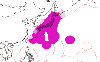


The Genesis of Maritime Jurisdictions
The concept of the Exclusive Economic Zone (EEZ) emerged as a critical development in the evolution of international maritime law, formally codified in the 1982 United Nations Convention on the Law of the Sea (UNCLOS). Prior to UNCLOS, the extent of a nation's maritime jurisdiction was often a point of contention, with varying claims and practices. The EEZ was conceived as a compromise, balancing the traditional freedoms of the high seas with the growing recognition of coastal states' rights to manage and exploit the resources of their adjacent continental margins.
It represents a distinct legal regime, neither full sovereignty nor open ocean, but a sui generis category of jurisdiction focused on economic exploitation and resource management within a defined seaward boundary.
Resource Rights and Responsibilities Beyond Territorial Limits
Within its EEZ, a sovereign state possesses specific sovereign rights for the purpose of exploring and exploiting, conserving, and managing the natural resources, whether living or non-living, of the waters superjacent to the seabed and of the seabed and its subsoil. This encompasses a vast array of resources, including fisheries, minerals, and hydrocarbons. Furthermore, the EEZ grants rights related to other activities for the economic exploitation and exploration of the zone, such as the production of energy from the water, currents, and winds.
However, these rights come with significant responsibilities. Coastal states are obligated to manage these resources sustainably, preventing overexploitation and ensuring the protection of the marine environment. They must also respect the rights of other states, particularly the freedom of navigation and overflight, which remain unimpeded within the EEZ.
Defining the Maritime Frontier
The geographical extent of an EEZ is precisely defined by UNCLOS. It begins at the seaward boundary of the territorial sea, which extends up to 12 nautical miles from the baselines from which the breadth of the territorial sea is measured. From this point, the EEZ extends further to a distance of 200 nautical miles from the baselines.
This 200-nautical-mile limit has become a near-universal standard, significantly shaping the geopolitical landscape of the world's oceans. It effectively delineates vast areas of the ocean floor and water column, granting significant economic control to coastal nations. The term 'maritime continental margin' is sometimes used colloquially, but the EEZ is a distinct legal concept that does not automatically include the entire continental shelf beyond the 200-nautical-mile limit, which has its own specific provisions under UNCLOS.
Geopolitical Implications and Resource Governance
The establishment of EEZs has profound geopolitical implications, influencing international relations, resource allocation, and maritime security. For many island nations and countries with extensive coastlines, their EEZs represent a substantial portion of their national territory and economic potential, often far exceeding their land area. This has led to complex negotiations and occasional disputes over overlapping claims, particularly in regions with narrow seas or extensive continental shelves.
Effective governance of EEZs requires robust legal frameworks, monitoring capabilities, and international cooperation to ensure sustainable resource management, prevent illegal fishing, and maintain maritime peace. The management of these zones is a continuous challenge, requiring adaptation to new technologies and evolving environmental concerns.
Go deeper
Based on content from Wikipedia · Licensed under CC BY-SA 4.0