

Granma Province: Cuba's Amazing Land!
Images

Yara (Cuban municipal map)

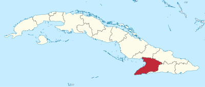


Geomorphology and Climatology of Granma Province
Granma Province occupies a strategic position in southeastern Cuba, presenting a complex geomorphological profile. Its territory encompasses coastal plains adjacent to the Gulf of Guacanayabo, which gradually ascend into more rugged interior terrains, potentially including foothills of the Sierra Maestra mountain range. This varied topography dictates a spectrum of microclimates, though the province generally experiences a tropical savanna climate, marked by high average temperatures and distinct wet (May to October) and dry (November to April) seasons.
The coastal areas are influenced by maritime factors, including sea breezes and potential for tropical storm activity. The presence of rivers and fertile valleys supports significant biodiversity and agricultural potential. Understanding these geographical underpinnings is crucial for appreciating the province's resource management, settlement patterns, and vulnerability to environmental changes.
Historical Significance and Revolutionary Legacy
Granma Province holds a profound place in Cuban history, most notably as the landing site of Fidel Castro's Granma yacht in December 1956, an event that initiated the Cuban Revolution. This singular event imbues the province with immense symbolic and historical weight. Beyond this pivotal moment, its capital, Bayamo, is one of Cuba's oldest cities, founded in 1513, and played a role in early colonial administration and subsequent independence struggles.
Manzanillo, as a significant port, has historically been a center for trade, emigration, and strategic importance. The province's name itself is a direct reference to this revolutionary legacy, underscoring its enduring connection to the formation of modern Cuba and its political identity.
Socio-Cultural Dynamics and Identity in Granma
The socio-cultural landscape of Granma Province is a vibrant reflection of Cuba's broader national identity, yet possesses distinct regional characteristics. Spanish is the lingua franca, shaping communication and cultural expression. The population, Granmenses, likely exhibits a blend of influences from indigenous, European, and African heritage, common across the Caribbean.
Daily life is a dynamic interplay between urban centers like Bayamo, the administrative and cultural heart, and the bustling port of Manzanillo, a hub of economic and social exchange. Cultural expressions, including music, dance, literature, and cuisine, are deeply rooted in tradition while evolving with contemporary influences. The province's unique historical narrative, particularly its revolutionary connection, further shapes a strong sense of local pride and identity.
Economic Structure and Development in Granma
The economic framework of Granma Province is multifaceted, relying on key sectors to drive its development. Agriculture remains a fundamental pillar, with the fertile lands likely supporting the cultivation of staple crops such as sugarcane, coffee, citrus fruits, and various vegetables, contributing significantly to both local consumption and national exports. The strategic location of Manzanillo as a port city is critical for facilitating trade, enabling the import of necessary goods and the export of provincial products. Industrial activities may also be present, potentially linked to agricultural processing or resource extraction, as suggested by the mention of Pilón.
The economic well-being of Granma's population is intrinsically linked to the performance of these sectors, highlighting the province's role within Cuba's national economic strategy.
Governance and Educational Frameworks
Granma Province operates within Cuba's centralized governmental structure, with its capital, Bayamo, serving as the seat of provincial administration. The provincial government is responsible for implementing national policies and managing local affairs, including public services, infrastructure development, and economic planning. Education is a high priority in Cuba, and Granma Province is no exception. The province likely hosts a comprehensive educational system, from primary schools to secondary institutions and potentially vocational training centers or higher education facilities.
This commitment to education aims to foster a skilled workforce and ensure widespread literacy and civic engagement among its population, reflecting Cuba's national emphasis on human capital development.
See also
Frequently Asked Questions
Where is Granma Province located in Cuba?+
Why is Granma Province important in Cuban history?+
What kind of weather does Granma Province have?+
What do people in Granma Province do for a living?+
What are the main towns in Granma Province?+
Based on content from Wikipedia · Licensed under CC BY-SA 4.0