

Lake Pontchartrain
Images

New Orleans and Lake Pontchartrain


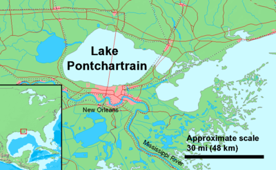

Hydrology and Ecological Dynamics of a Vital Estuary
Lake Pontchartrain, situated in southeastern Louisiana, is a significant estuarine system characterized by its unique hydrological dynamics. Covering an expansive 630 square miles, it represents a critical interface between terrestrial freshwater sources and the saline waters of the Gulf of Mexico. The lake's classification as an estuary is due to its limited but crucial connection to the open sea, which allows for a constant exchange of water, influencing salinity levels and nutrient transport.
Its roughly oval shape, measuring approximately 40 miles west to east and 24 miles south to north, dictates water circulation patterns. The average depth of 12 to 14 feet is relatively shallow, but dredging operations maintain deeper shipping channels, facilitating maritime activities. This dynamic environment supports a diverse array of flora and fauna, making it a vital ecological corridor.
The lake's water levels and salinity are influenced by precipitation, riverine inflow, and tidal action from the Gulf, creating a complex and ever-changing ecosystem that is sensitive to environmental shifts and human impact.
The Lake Pontchartrain Causeway
Spanning the vast expanse of Lake Pontchartrain is the Lake Pontchartrain Causeway, an engineering marvel that stands as the longest continuous bridge over water in the world. This monumental structure, stretching for over 24 miles, is not merely a transportation artery but a symbol of human ambition and technological prowess. Its construction involved the placement of thousands of concrete pilings driven deep into the lakebed, supporting a roadway that appears to float on the water's surface.
The sheer scale of the Causeway offers a unique perspective on the Earth's curvature, a phenomenon observable to those traversing its length. Beyond its primary function of connecting communities, the Causeway also serves as a critical piece of infrastructure, facilitating commerce and daily life for millions. The presence of other structures, such as power line towers anchored by caissons, further underscores the lake's role as a conduit for essential services across the region.
Socio-Economic and Cultural Significance
Lake Pontchartrain is deeply interwoven with the socio-economic and cultural fabric of southeastern Louisiana. The lake's shores and surrounding areas are home to a substantial population, distributed across six distinct parishes: St. Tammany, Orleans, Jefferson, St.
John the Baptist, St. Charles, and Tangipahoa. Historically, the lake has been a cornerstone of regional development, serving as a vital resource for fishing, transportation, and recreation.
Today, it continues to drive economic activity through industries such as commercial and recreational fishing, tourism, and maritime trade. The lake's presence has shaped the unique cultural identity of the region, influencing traditions, cuisine, and the overall lifestyle of its inhabitants. Its ecological health is paramount, directly impacting the livelihoods of those dependent on its resources and the recreational opportunities it provides for residents and visitors alike.
Governance and Environmental Stewardship
The management and preservation of Lake Pontchartrain involve a complex interplay of governmental bodies and environmental stewardship initiatives. Defined water boundaries were established in 1979, providing a framework for its administration across multiple parishes. Various state and federal agencies are involved in monitoring water quality, managing fisheries, and implementing conservation strategies to protect this vital estuarine system.
The challenges facing Lake Pontchartrain are multifaceted, including issues related to water pollution, habitat degradation, and the impacts of climate change. Efforts to address these challenges often involve collaborative approaches, bringing together scientists, policymakers, community groups, and the public to ensure the long-term health and sustainability of the lake and its surrounding environment. Education plays a crucial role in fostering a sense of responsibility and promoting practices that safeguard this invaluable natural resource for future generations.
See also
Frequently Asked Questions
What is Lake Pontchartrain?+
Why is the Lake Pontchartrain Causeway so special?+
How deep is Lake Pontchartrain?+
What kinds of animals live in Lake Pontchartrain?+
How does Lake Pontchartrain help people in Louisiana?+
Based on content from Wikipedia · Licensed under CC BY-SA 4.0