

Watsons Bay
Images

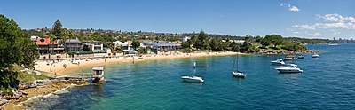
Sydney from Watsons Bay



Geomorphological Significance and Harbour Dynamics
Watsons Bay occupies a geologically significant position at the terminus of the South Head peninsula, a landform shaped by ancient geological processes and the relentless action of the sea. Its western flank is defined by Port Jackson, Sydney Harbour’s primary entrance, offering a naturally sheltered bay that has historically served as a crucial anchorage and maritime gateway. This sheltered aspect contrasts sharply with its eastern boundary, dominated by The Gap, a series of dramatic sandstone cliffs facing the open Pacific Ocean.
These cliffs are a testament to coastal erosion, providing stark, windswept vistas and a powerful display of oceanic forces. The bay’s strategic location offers commanding views across the harbor towards the Sydney Harbour Bridge and the North Head, highlighting its role as a natural vantage point within the vast Sydney metropolitan area. The suburb’s topography, therefore, presents a duality: the calm, protected waters of the harbor versus the exposed, dynamic energy of the Pacific.
Historical Evolution
The historical trajectory of Watsons Bay is intrinsically linked to its geography. The sheltered bay provided an essential natural harbor, making it a point of interest from the earliest days of European settlement in Sydney. Its role as a maritime location, coupled with its elevated position offering strategic views, has shaped its development.
Over time, the area transitioned from a functional maritime site to a sought-after residential locale. The Municipality of Woollahra, which governs Watsons Bay, is known for its affluent coastal suburbs, and Watsons Bay fits this profile, attracting residents who value its unique blend of natural beauty and proximity to the city. The development patterns reflect a careful balance between preserving the dramatic natural landscape and accommodating urban growth, making it a case study in coastal urban planning.
Socio-Economic Fabric and Lifestyle Implications
Watsons Bay presents a compelling socio-economic profile, characterized by its exclusivity and the high value placed on its unique environmental assets. As a predominantly residential suburb, its economy is less about heavy industry and more about the services that cater to its residents and the visitors drawn by its scenic appeal. The stunning harbor and ocean views contribute significantly to property values, making it one of Sydney’s more affluent areas.
Many residents likely engage in professional careers within Sydney’s central business district, commuting daily and contributing to the broader metropolitan economy. The lifestyle in Watsons Bay is often associated with coastal living, offering a retreat from the urban bustle while remaining connected to the city’s amenities. This creates a distinct community identity, deeply intertwined with the natural environment.
Governance and Urban Planning Considerations
Governed by the Municipality of Woollahra, Watsons Bay’s urban planning and development are managed within a framework that seeks to balance residential needs with the preservation of its significant natural heritage. The local government plays a crucial role in managing access to its scenic lookouts, maintaining coastal paths, and ensuring that development respects the unique character of the area. The suburb’s location, 11 kilometers north-east of Sydney’s central business district, positions it as an accessible yet distinct part of the metropolitan landscape.
Planning decisions here often involve careful consideration of environmental impacts, particularly concerning the sensitive coastal ecosystems and the visual amenity of the harbor and ocean frontages. The governance structure aims to maintain Watsons Bay’s appeal as a desirable place to live while protecting its natural and scenic qualities for future generations.
Education and Research Opportunities
While Watsons Bay itself is primarily a residential area, its unique geographical setting and proximity to Sydney’s academic institutions create opportunities for education and research. The dramatic coastal environment, with its distinct harbor and ocean interfaces, serves as a natural laboratory for studies in marine biology, coastal geomorphology, and environmental science. Students and researchers from universities and colleges located within the greater Sydney area can utilize Watsons Bay for fieldwork, observing phenomena such as tidal influences, wave action on cliffs, and the biodiversity of harbor ecosystems.
The educational landscape for residents typically involves accessing schools within the broader Municipality of Woollahra or commuting to specialized institutions within Sydney, benefiting from the city’s extensive educational infrastructure.
See also
Frequently Asked Questions
What is Watsons Bay?+
Why do boats like to stay in Watsons Bay?+
Where can you see the Sydney Harbour Bridge from Watsons Bay?+
What are The Gap cliffs and why are they special?+
How does Watsons Bay balance homes and nature?+
Based on content from Wikipedia · Licensed under CC BY-SA 4.0