

Saint-Charles River (Quebec City)
Images

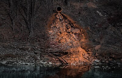
Pointe-st-charles / contaminated, with a view


The Hydrological Dynamics of an Urban River
The Saint-Charles River serves as the principal watercourse traversing Quebec City, a vital geographical feature whose hydrological behavior is intrinsically linked to the urban environment it flows through. Its surface undergoes a significant transformation annually, typically freezing from early December through late March. This period of ice cover is not merely an aesthetic phenomenon but a critical factor influencing the river's ecosystem and human interaction.
Safe circulation on the ice is generally feasible from late December to early March, a testament to the region's climate. The river's water level is highly variable, directly responding to seasonal precipitation patterns and snowmelt. This dynamic fluctuation is most pronounced during the spring flood, usually occurring in March or April, a period of heightened water flow that shapes the riverbanks and influences downstream conditions.
Understanding these hydrological cycles is essential for urban planning and environmental management within Quebec City.
A River's Enduring Indigenous Legacy
The Saint-Charles River carries a name from its earliest human history: Akiawenrahk, as known by the Wendat people. This appellation is more than just a label; it represents a profound and enduring connection between an Indigenous nation and the land they inhabited for millennia. The river was not merely a geographical marker but likely a source of sustenance, a transportation route, and a spiritual focal point.
Its presence has undoubtedly shaped the settlement patterns and cultural development of the region long before European arrival. Recognizing Akiawenrahk allows for a deeper appreciation of the river's historical depth, acknowledging the continuous human presence and the rich heritage that predates modern Quebec City. This historical context is crucial for understanding the river's significance beyond its contemporary urban function.
The River as a Catalyst for Urban Development
The Saint-Charles River has played a foundational role in the historical development of Quebec City. As with many major urban centers, its location was likely chosen due to the river's strategic advantages, offering a source of fresh water, a means of transport, and a natural defense. Over centuries, the riverbanks have witnessed the growth of settlements, the establishment of industries, and the evolution of the city's infrastructure.
The river's consistent flow and its seasonal changes, including the predictable spring flood, have necessitated adaptation and engineering solutions from its inhabitants. Its role as a central artery has influenced urban planning, trade routes, and the very fabric of city life. The river's continued presence is a constant reminder of the historical forces that have shaped Quebec City into the vibrant urban center it is today.
Navigating the Seasonal Extremes
The Saint-Charles River presents a fascinating case study in managing seasonal hydrological extremes within an urban setting. The annual freeze-up, typically from December to March, transforms the river into a frozen landscape. While this offers unique recreational opportunities, it also necessitates careful monitoring to ensure safety, with reliable ice conditions generally occurring from late December to early March.
Conversely, the spring flood, usually in March or April, presents challenges related to increased water volume and potential erosion. The river's water level is a sensitive indicator of regional weather patterns, making its monitoring crucial for flood prediction and mitigation efforts. The interplay between the river's frozen state in winter and its swollen condition in spring highlights the powerful natural forces that continue to shape the urban environment of Quebec City, requiring ongoing scientific study and adaptive management strategies.
Contemporary Relevance and Environmental Considerations
In the modern era, the Saint-Charles River remains a critical component of Quebec City's environmental and social landscape. While its historical role as a primary transportation route has diminished with advancements in technology, its ecological importance persists. The river's health is directly tied to the well-being of the surrounding urban ecosystem.
Issues such as water quality, habitat preservation, and the impact of urban runoff are ongoing concerns that require diligent management. The river's ability to freeze and flood also continues to influence local infrastructure and emergency preparedness. Furthermore, the rediscovery and celebration of its Indigenous name, Akiawenrahk, foster a greater understanding of cultural heritage and promote reconciliation.
The Saint-Charles River, therefore, serves as a living link between Quebec City's past, present, and future, demanding continued attention to its environmental stewardship and historical significance.
See also
Frequently Asked Questions
What is the Saint-Charles River in Quebec City?+
When does the Saint-Charles River freeze and when is it safe to walk on the ice?+
Why does the Saint-Charles River flood in spring?+
What was the original name of the Saint-Charles River?+
How has the Saint-Charles River helped build Quebec City?+
Based on content from Wikipedia · Licensed under CC BY-SA 4.0