

Rhumb Line: The Wobbly Way to Go!
Images
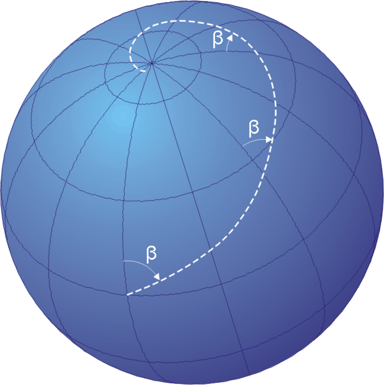
Rhumb line
Geometric Properties of the Loxodrome
The rhumb line, or loxodrome, is a curve on the surface of a sphere that intersects all meridians of longitude at a constant angle. Mathematically, if we consider a sphere with radius R, and a path defined by spherical coordinates (latitude ϕ and longitude λ), a rhumb line satisfies the differential equation dλ/dϕ = ± cot(α), where α is the constant angle the line makes with the meridians. This equation reveals that the change in longitude is proportional to the change in latitude, scaled by the cotangent of the bearing angle.
On a Mercator projection, where meridians are parallel vertical lines and parallels of latitude are horizontal lines, the rhumb line is indeed a straight line. This is because the Mercator projection is conformal, meaning it preserves angles locally. However, on a spherical globe, a rhumb line is generally a logarithmic spiral that approaches, but never reaches, the poles, unless the bearing is exactly 0° or 180° (true north or south), in which case it coincides with a meridian.
Historical Reliance and Cartographic Representation
The rhumb line has been indispensable to maritime and aerial navigation for centuries. Its primary advantage lies in its simplicity for navigators: maintaining a constant compass heading is far easier than continuously adjusting course to follow a great-circle route. This predictability was crucial during the Age of Discovery and subsequent eras of exploration and trade.
Cartographers, notably Gerardus Mercator in the 16th century, developed the Mercator projection specifically to represent rhumb lines as straight segments. This projection revolutionized navigation by allowing sailors to plot a course by simply drawing a straight line between their current position and destination, then reading the compass bearing. While the Mercator projection significantly distorts areas and distances, especially at higher latitudes, its utility in depicting rhumb lines made it the standard for nautical charts for a long time.
The Great Circle vs. Rhumb Line
The shortest distance between two points on a sphere is along a great-circle route, which is the arc of a circle that lies on a plane passing through the center of the sphere. While geometrically more efficient, following a great-circle route necessitates a continuously changing compass bearing. For instance, flying from London to New York along a great circle involves a path that initially heads northeast, then gradually turns northwest.
This constant adjustment is complex for manual navigation and requires sophisticated equipment for precise execution. In contrast, a rhumb line offers a constant bearing, simplifying the navigational task. The trade-off is that a rhumb line path is typically longer than a great-circle path, except for journeys along the equator or along a meridian.
The decision between using a rhumb line or a great-circle route often depends on the distance of the journey, the available technology, and the acceptable margin of error.
Modern Applications and Enduring Relevance
Despite the advent of advanced Global Navigation Satellite Systems (GNSS) like GPS, which can precisely calculate and guide along great-circle routes, the rhumb line retains its importance. In aviation, pilots often use rhumb lines for shorter flights or specific segments of longer journeys due to their ease of visualization and execution on navigation charts. Similarly, maritime navigation still employs rhumb lines, especially when plotting courses on traditional paper charts or for maintaining a steady heading.
Furthermore, understanding rhumb lines is fundamental to comprehending the principles of map projections and spherical geometry. Even in digital navigation systems, the underlying algorithms often account for or can calculate rhumb line paths, demonstrating its enduring legacy as a practical and conceptually significant navigational tool.
Go deeper
Frequently Asked Questions
What is a rhumb line?+
Why do sailors use rhumb lines?+
How does a rhumb line look on a map?+
Is a rhumb line the shortest path between two places?+
Do airplanes still use rhumb lines?+
Based on content from Wikipedia · Licensed under CC BY-SA 4.0