
Maritime Boundary: The Ocean's Invisible Fences!
Images

File:RIAN archive 942200 Border guards of the Federal Security Service pursuing trespassers of the maritime boundary during exercises in Kaliningrad region.jpg


Key Facts
Where Does the Ocean Belong?
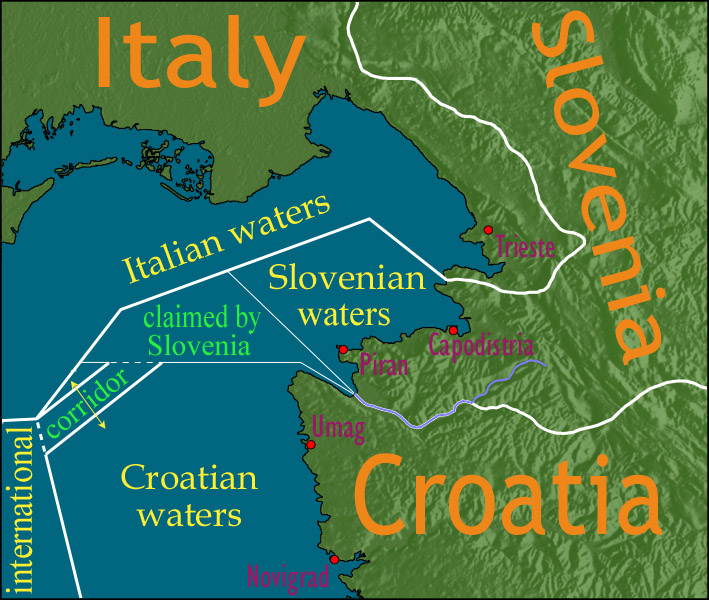
Have you ever played in a park and known where your yard ends and your neighbor's begins? Countries have invisible lines in the ocean too, called maritime boundaries! These lines help decide who gets to explore and use the treasures in the water, like fish and sparkly minerals. They usually start from the land and stretch out into the big blue sea, like a country's watery backyard.
Why Do We Need Ocean Lines?
These ocean lines are super important! They're like rules for sharing the sea. They help make sure countries can find and use the yummy fish and important stuff deep in the ocean without arguing. It's like having a special zone where a country is in charge of its own ocean treasures, making sure everyone plays fair in the big, watery world.
Ocean Lines and Special Zones!
Sometimes, these ocean lines create special zones! One zone is called 'territorial waters,' which is like the closest part of the ocean to the land, and the country has lots of control there. Then there's the 'exclusive economic zone,' which is much bigger and lets a country look for fish and minerals way out in the ocean. It's like having different levels of ownership in the sea!
Not Always Easy to Draw!
Drawing these ocean lines isn't always as simple as drawing a straight line on paper. Sometimes, countries have trouble agreeing on exactly where the lines should go. It can be tricky because the ocean is so big and has so many interesting things. But drawing these lines helps keep things peaceful and organized in the amazing underwater world.
Based on content from Wikipedia · Licensed under CC BY-SA 4.0