

Liancourt Rocks
Images

Liancourt Rocks Map


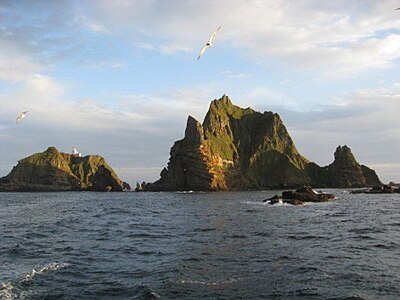
Geographical Context and Marine Environment
The Liancourt Rocks, known as Dokdo in Korea and Takeshima in Japan, are a geologically significant cluster of islets situated in the Sea of Japan. Their location, approximately equidistant between the Korean Peninsula and the Japanese archipelago, places them in a region of considerable geopolitical and economic interest. The formation comprises two principal islets and 35 smaller rocks, with a total surface area of 19 hectares.
The West Islet reaches a maximum elevation of 168.5 meters, a height comparable to a mid-rise building. The surrounding waters are part of a highly productive marine ecosystem, renowned for their abundant fish stocks, which are crucial for the fisheries of both South Korea and Japan. Furthermore, geological surveys suggest the potential for substantial natural gas hydrate deposits beneath the seabed in this area, a factor that significantly elevates the strategic importance of the islets.
Etymology and Historical Naming Conventions
The nomenclature of the Liancourt Rocks reflects their contested status. The Korean name, Dokdo, is deeply ingrained in national consciousness and historical narratives. The Japanese name, Takeshima, is similarly central to Japanese claims.
The English designation, Liancourt Rocks, originates from a specific historical maritime encounter. In 1849, the French whaling vessel Le Liancourt narrowly avoided shipwreck on these islets. This incident led to the rocks being charted and named by European navigators, illustrating the era's global maritime exploration and the subsequent international recognition of geographical features, even those subject to territorial disputes.
The existence of multiple names underscores the differing historical perspectives and claims of the nations involved.
Economic Drivers
The economic value of the Liancourt Rocks is multifaceted. Primarily, they are situated within some of the most productive fishing grounds in the region. These waters support a diverse array of commercially valuable fish species, making the area a critical zone for the fishing industries of both South Korea and Japan.
The sustainable management and access to these fisheries are of paramount economic importance. Beyond the immediate fishery resources, the potential for significant natural gas reserves represents a future economic boon. The exploitation of these subsea resources could provide substantial energy and revenue, further intensifying the strategic interest in controlling the territory from which such resources could be accessed.
The Sovereignty Dispute
The Liancourt Rocks are the subject of an enduring sovereignty dispute, primarily between South Korea and Japan. South Korea currently administers the islets, classifying them administratively as Dokdo-ri, Ulleung-eup, Ulleung County, North Gyeongsang Province. Japan, however, contests this administration and claims the islets as Takeshima, part of Okinoshima, Oki District, Shimane Prefecture. North Korea also asserts a claim to the territory.
This dispute is rooted in differing historical interpretations of discovery, occupation, and administration dating back centuries. The islets' strategic location, coupled with their rich fishing grounds and potential energy resources, makes them a significant geopolitical flashpoint, influencing diplomatic relations and national security considerations in Northeast Asia.
Administration and Governance
Despite the ongoing territorial dispute, South Korea exercises effective administrative control over the Liancourt Rocks. This control is manifested through the presence of a small South Korean police detachment, a lighthouse, and limited civilian infrastructure. The islets are officially designated as part of Ulleung County in North Gyeongsang Province, reflecting South Korea's assertion of sovereignty.
Japan, conversely, maintains its claim through administrative classification within Shimane Prefecture and diplomatic channels. The differing administrative frameworks highlight the core of the dispute: while one nation exercises de facto control, the other maintains a de jure claim based on its historical and legal interpretations. This dual classification system is a key element in the ongoing international legal and political debate.
See also
Based on content from Wikipedia · Licensed under CC BY-SA 4.0