

Kimberley (Western Australia)
Images

Geology of Kimberley (Western Australia) Tectonic Evolution (b)




Geographical Context and Boundaries
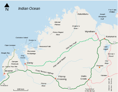
The Kimberley constitutes the northernmost of Western Australia's nine administrative regions, a vast territory defined by its unique geographical position and natural boundaries. To its west lies the expansive Indian Ocean, and to the north, the Timor Sea. Its southern frontier is marked by the arid expanse of the Great Sandy and Tanami deserts, which transition into the Pilbara region.
To the east, the Kimberley shares a border with the Northern Territory. This strategic location places it at a crossroads of marine and terrestrial influences, shaping its climate, biodiversity, and human history. The sheer scale of the Kimberley is staggering; it encompasses an area of approximately 423,517 square kilometers, making it larger than many European countries.
This immense size contributes to its diverse microclimates and varied landscapes, from coastal plains to rugged inland plateaus.
Geological Marvels and Ecological Diversity
The Kimberley is a land of profound geological age, featuring some of the oldest rock formations on Earth, dating back billions of years. This ancient bedrock has been sculpted over millennia by powerful natural forces, resulting in a landscape of unparalleled dramatic beauty. Iconic features include the Bungle Bungle Range with its distinctive beehive-shaped domes, the vast, ancient gorges of the Kimberley Plateau, and the rugged coastline dotted with islands and inlets.
The region experiences a tropical savanna climate, characterized by distinct wet and dry seasons. The wet season, typically from November to April, brings heavy rainfall that transforms the landscape, fueling spectacular waterfalls and lush vegetation. The dry season, from May to October, sees clear skies and cooler temperatures, making it ideal for exploration.
This climatic duality supports a rich biodiversity, with unique flora and fauna adapted to these challenging yet rewarding conditions, including endemic species found nowhere else on the planet.
Historical Naming and Indigenous Heritage
The European naming of the Kimberley in 1879 by surveyor Alexander Forrest, in honor of John Wodehouse, 1st Earl of Kimberley, represents a relatively recent chapter in a story that spans tens of thousands of years. The Kimberley is the ancestral home of numerous Aboriginal language groups, including the Yawuru, Nyikina, Warrwa, Karajarri, and Bardi peoples, among others. These Indigenous Australians have maintained a deep spiritual and cultural connection to the land, sea, and sky, passing down intricate knowledge systems, laws, and traditions through oral histories, art, and ceremony.
Their stewardship of the land has shaped its cultural landscape for millennia, and their enduring presence is a fundamental aspect of the Kimberley's identity. Understanding the Kimberley requires acknowledging this profound Indigenous heritage alongside its colonial history.
Economic Activities and Development
The economy of the Kimberley is primarily based on its natural resources and burgeoning tourism sector. Vast cattle stations, known as pastoral leases, cover a significant portion of the region, making beef production a cornerstone of its economy. The tourism industry is increasingly vital, attracting visitors drawn to the region's spectacular natural attractions, such as the Horizontal Falls, El Questro Wilderness Park, and the ancient rock art sites.
These visitors contribute significantly to local economies, supporting accommodation, tour operators, and hospitality services. Other economic activities include mining, though less dominant than in some other Western Australian regions, and fishing. The development of infrastructure, particularly transportation and communication networks, remains a key challenge and focus for sustainable economic growth in this remote and expansive area.
Governance, Education, and Future Outlook
The Kimberley region is governed as part of Western Australia, with local governance provided by various local government authorities responsible for services within their respective areas. The region faces unique challenges related to its remoteness, including access to services, healthcare, and education. Educational initiatives in the Kimberley often focus on bridging geographical barriers and incorporating Indigenous knowledge into curricula.
Efforts are made to provide quality education from early childhood through to tertiary levels, often utilizing a mix of physical institutions and distance learning. The future of the Kimberley is increasingly focused on sustainable development, balancing economic opportunities with the preservation of its unique environment and the empowerment of its Indigenous communities. Managing the impacts of climate change and ensuring the long-term viability of its natural and cultural assets are critical considerations for its future.
See also
Frequently Asked Questions
Where is the Kimberley located?+
What makes the Kimberley's landscape special?+
What is the weather like in the Kimberley?+
Who are the Indigenous peoples of the Kimberley?+
What can visitors do in the Kimberley?+
Based on content from Wikipedia · Licensed under CC BY-SA 4.0