

Katabatic Wind
Images

Katabatic-wind lv

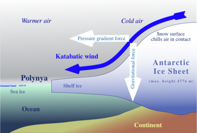


The Physics of Gravitational Air Drainage
Katabatic winds are fundamentally a manifestation of gravity acting upon a density-driven flow. The process originates when air situated over elevated, often cold, surfaces such as glaciers, ice sheets, or high mountain plateaus cools radiatively during the night or due to prolonged exposure to cold conditions. This cooling increases the air's density relative to the warmer, less dense air at lower elevations.
Once this density difference surpasses a certain threshold, gravity compels the denser air to accelerate downslope. The magnitude of the katabatic wind is influenced by several factors: the temperature contrast between the descending air and the ambient air, the slope angle of the terrain, and the presence of obstacles or channeling effects within valleys. Unlike thermally driven winds, the primary impetus here is the potential energy released as the denser air mass seeks a lower gravitational potential.
This can result in surprisingly high wind speeds, particularly in confined topographic features like fjords or steep valleys.
Global Manifestations and Topographic Influence
The geographical distribution of katabatic winds is extensive, occurring wherever significant elevation gradients coincide with conditions conducive to air cooling. Polar regions, particularly Antarctica and Greenland, are prime locations for intense katabatic winds due to their vast, high ice sheets and extremely low surface temperatures. The relentless drainage of cold air from these ice domes creates some of the strongest and most persistent katabatic flows on Earth, such as the notorious Piteraq wind of Greenland.
Mountainous regions worldwide also experience katabatic winds, often manifesting as localized mountain or valley breezes. Examples include the Bora wind along the Adriatic coast, the Santa Ana winds in Southern California (which are complex, involving downslope flow but also adiabatic warming due to compression), and the Oroshi winds in Japan. The specific topography plays a crucial role in channeling and intensifying these winds, transforming a general downslope flow into a focused, powerful gust.
Ecological and Climatological Significance
Katabatic winds exert a profound influence on local and regional climates, ecosystems, and human activities. In polar environments, they are instrumental in shaping ice sheet dynamics, influencing snow accumulation patterns, and contributing to coastal erosion. They can transport cold air masses far from their source, significantly lowering local temperatures and affecting weather systems.
For instance, the persistent cold air drainage from ice sheets can influence sea ice formation and ocean circulation patterns. In mountainous regions, these winds can affect vegetation distribution, frost patterns, and agricultural viability. For human endeavors, understanding katabatic winds is vital for aviation safety, wind energy development, and predicting extreme weather events.
Their ability to rapidly change temperature and wind conditions makes them a critical factor in hazard assessment and preparedness, especially in coastal and mountainous communities.
Distinguishing Katabatic from Other Downslope Winds
It is crucial to differentiate katabatic winds from other types of downslope winds, such as Föhn or Chinook winds. While all involve air moving from higher to lower elevations, the underlying mechanisms differ significantly. Föhn and Chinook winds are primarily rain shadow winds.
As air is forced upslope on one side of a mountain range, it cools, condenses, and precipitates its moisture. When this drier air descends on the leeward side, it warms adiabatically (due to compression) and becomes significantly warmer and drier than the air on the windward side. In contrast, katabatic winds are driven by the density of the air itself, which is primarily a function of its temperature.
Therefore, katabatic winds remain cool or cold as they descend, often bringing a sharp drop in temperature to the areas they reach. This fundamental difference in thermal behavior has distinct implications for local weather and climate.
See also
Frequently Asked Questions
What is a katabatic wind?+
Why do katabatic winds happen at night?+
Where do the strongest katabatic winds usually occur?+
How can katabatic winds affect people and nature?+
How are katabatic winds different from other mountain breezes?+
Based on content from Wikipedia · Licensed under CC BY-SA 4.0