

Geostationary Orbit: Satellites That Stay Put!
Images

Geostationary orbit





The Physics of Apparent Stillness
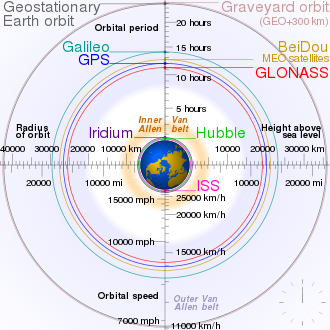
A geostationary orbit (GEO) is a specific type of geosynchronous orbit that lies directly above the Earth's equator. The defining characteristic of GEO is that a satellite in this orbit has an orbital period that exactly matches Earth's rotational period (one sidereal day, approximately 23 hours, 56 minutes, and 4 seconds). Crucially, the orbit is circular and has an inclination of zero degrees relative to the equator.
This precise alignment ensures that the satellite's angular velocity matches Earth's angular velocity, causing it to appear stationary from any fixed point on the planet's surface. The altitude required for this orbit is approximately 35,786 kilometers (22,236 miles) above the mean sea level. At this altitude, the gravitational force of the Earth precisely balances the satellite's inertial tendency to move in a straight line, maintaining its circular path.
Historical Genesis and Technological Evolution
The concept of geostationary satellites was first proposed by science fiction writer Arthur C. Clarke in his 1945 paper 'Extra-Terrestrial Relays.' He envisioned using satellites in equatorial orbits to provide global radio coverage. The actual realization of this concept began in the mid-20th century with the dawn of the space age.
The first successful geostationary satellite, Syncom 3, was launched by NASA in 1964. It was instrumental in relaying live television coverage of the Tokyo Olympics, demonstrating the immense potential of this orbital configuration for global communication. Subsequent decades saw rapid advancements, with more sophisticated satellites offering higher bandwidth, improved resolution for Earth observation, and greater reliability, solidifying GEO's role in modern infrastructure.
Indispensable Applications and Global Impact
Geostationary orbits are fundamental to numerous critical global services. In telecommunications, GEO satellites are the backbone for direct broadcast satellite television (DBS), satellite radio, and international telephone communications, providing uninterrupted service to fixed ground antennas. Meteorologically, geostationary weather satellites, such as the GOES and Meteosat series, offer continuous monitoring of atmospheric conditions, enabling accurate forecasting, tracking of severe weather events like hurricanes and typhoons, and climate research.
They provide vital data for disaster management and public safety. Furthermore, GEO is utilized for navigation augmentation systems, scientific research, and even some military reconnaissance, underscoring its multifaceted importance in contemporary society.
Challenges and Future Prospects
Despite its advantages, GEO is not without its challenges. The high altitude means that signals experience a noticeable latency (delay) due to the vast distance, which can be problematic for real-time interactive applications like online gaming or high-frequency trading. Launching satellites into GEO is also more energy-intensive and costly than placing them into lower Earth orbits.
The geostationary arc above the equator is a finite resource, leading to increasing congestion and the need for precise orbital slot management. Future developments may involve more efficient propulsion systems for station-keeping, advanced antenna technologies to mitigate latency, and potentially the use of inclined geosynchronous orbits for specific regional coverage needs, though true geostationary orbits will likely remain critical for many applications.
Go deeper
Frequently Asked Questions
What is a geostationary orbit?+
Why does a geostationary satellite stay in one place in the sky?+
How high is a satellite in a geostationary orbit?+
What can geostationary satellites help us with?+
What are some problems with geostationary satellites?+
Based on content from Wikipedia · Licensed under CC BY-SA 4.0