
Equatorial coordinate system
Images

Equatorial coordinate system


Key Facts
Your Starry Address Book!
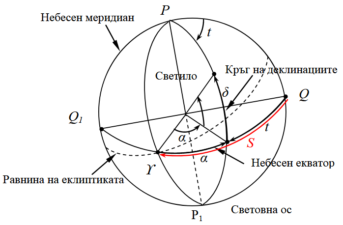
Have you ever wondered how scientists know exactly where to find a star, even though they are super far away? They use something called the equatorial coordinate system! Think of it like a special address book for the sky.
It helps everyone agree on where things are, just like your house has a street name and number. This system uses two main numbers to pinpoint anything in space, from a tiny moon to a giant galaxy. It's like giving every star its own unique zip code!
Who Drew the First Sky Map?
People have been looking up at the stars for thousands of years, trying to understand them. Ancient astronomers in places like Greece and Babylon were the first to try and map the sky. They noticed that stars seemed to move in patterns.
Over time, as people got better telescopes and learned more, they created more detailed sky maps. The equatorial coordinate system we use today is like a super-updated version of those very first star charts. It’s a system that has grown and improved over a very, very long time!
Why We Need a Sky Map
This sky map is super important for lots of reasons! It helps astronomers find new planets and study how stars change. It's also how we send rockets and satellites to space.
If you want to send a probe to Mars, you need to know exactly where Mars will be! This system helps scientists share information and work together. Without it, finding anything in the vastness of space would be like trying to find a specific grain of sand on a giant beach without a map.
It makes exploring the universe possible!
How to Find Your Way in Space
The equatorial coordinate system uses two main numbers, kind of like latitude and longitude on Earth. One number tells you how far north or south something is from the sky's equator, and the other tells you how far east or west it is. Imagine drawing lines across a giant ball.
These lines help us measure where everything is. It’s a clever way to divide the whole sky into tiny, manageable pieces so we can talk about them precisely. It makes the universe feel a little less confusing!
Based on content from Wikipedia · Licensed under CC BY-SA 4.0